

India Nepal Border Dispute
Why in news?
• The Indian continent is sweltering and it is not the summer heat. Amid Covid-19 pandemic India-Nepal border dispute has rose to a new height.
• Ever since India inaugurated a new motorable link road that makes connectivity to china border and which passes through Lipulekh Pass that Nepal claims as its own territory.
Importance of the route:
• The revamp of the trekking route to a motorable road is a boon to both pilgrims and traders.
• At present, the travel time to Kailash Man Sarovar takes around two to three weeks through Sikkim or Nepal routes.
• Lipulekh route had a trek of 90 Km through high altitude terrain and the Old Pilgrim faced lot of difficulties.
• Now, this yatra will get completed by vehicles.
• Additionally, this road follows the traditional pilgrim route for the Kailash Man Sarovar yatra.
• The newly constructed Lipulekh Pass links Uttarakhand with China’s Tibetan Autonomous Region.
• The pass is near the tri-junction of India, Nepal and China.
Historical Background:
• This territorial battle between the two neighboring countries has been brewing since ages.
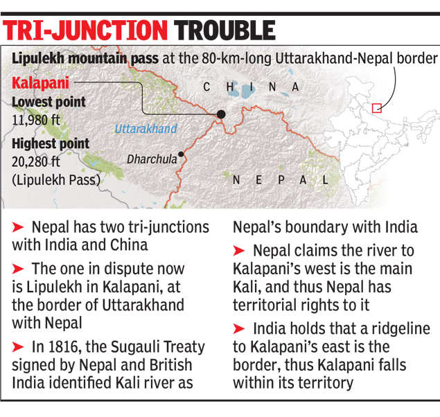
• The bone of contention is the Kalapani-Limpiadhura-Lipulekh trijunction between Nepal-India and China (Tibet). Located on the banks of the river Kali at an altitude of 3600m, the Kalapani territory lies at the eastern border of Uttarakhand in India and Nepal’s Sudurpashchim Pradesh in the West.
• India claims the area is part of Uttarakhand’s Pithoragarh district, while Nepal believes it to be part of its Dharchula district.
• While the territory is of strategic importance to India and Nepal, the issue is complicated by the contest over the historicity of cartographic evidence that both sides claim to be most accurate. The issue in itself goes back to the early 19th century, when the British ruled India and Nepal was a conglomeration of small kingdoms under the reign of King Prithvi Narayan Shah.
• By the second decade the British East India Company (EIC) established a strong hold of position in Indian Continent. By the early 19th century the EIC started expanding its territory and finally on 1st November 1814 EIC declared war on Nepal.
• The war went on for 2 years and finally it came to an end by signing off the Sugauli Treaty
• The Sugauli Treaty stated that Nepal ceded to British the whole of the lowlands between the Rivers Kali and Rapti.
• The Survey of India maps since the 1870s showed the area of Lipu Lekh down to Kalapani as part of British India.
• Both the Rana rulers of Nepal and the Nepalese Kings accepted the boundary and did not raise any objection with the government of India after India’s Independence
Recent developments and conflicts:
• Nepal has repugn that Mahakali river at Kalapani is not the Kali river. Further Nepal now postulated that the Kali river lies further west to the Lipu Lekh pass and claims both Kalapani & Susta belong to Nepal
• Nepal has deployed its armed forces and released new map claiming disputed area to be a part of Nepal’s territory. However, this move by Nepal has drawn a sharp criticism from India rejecting the map and has asked Nepal to refrain from taking such
For more such notes, Articles, News & Views Join our Telegram Channel.
Click the link below to see the details about the UPSC –Civils courses offered by Triumph IAS. https://triumphias.com/pages-all-courses.php