

Glacial Landforms and Cycle of Erosion
Relevance: Prelims/Mains: G.S paper I: Geography: Geomorphology: Glacial Landforms: Erosional and Depositional
Glacial Landforms and Cycle of Erosion
- A glacier is a moving mass of ice at speeds averaging few meters a day.
- Types of Glaciers: continental glaciers, ice caps, piedmont glaciers and valley glaciers.
- The continental glaciers are found in the Antarctica and in Greenland. The biggest continental ice sheet in
- Ice caps are the covers of snow and ice on mountains from which the valley or mountain glaciers originate.
- The piedmont glaciers form a continuous ice sheet at the base of mountains as in southern Alaska.
- The valley glaciers, also known as Alpine glaciers, are found in higher regions of the Himalayas in our country and all such high mountain ranges of the world.
- The largest of Indian glaciers occur in the Karakoram range, viz. Siachen (72 km), while Gangotri in Uttar Pradesh (Himalayas) is 25.5 km long.
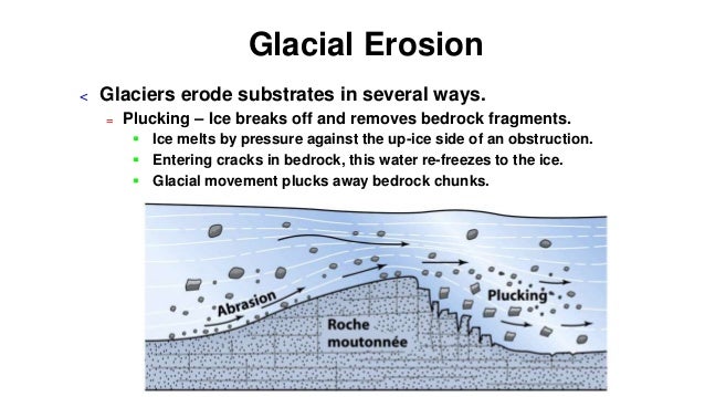
- A glacier is charged with rock debris which are used for erosional activity by moving ice.
- A glacier during its lifetime creates various landforms which may be classified into erosional and depositional landforms.
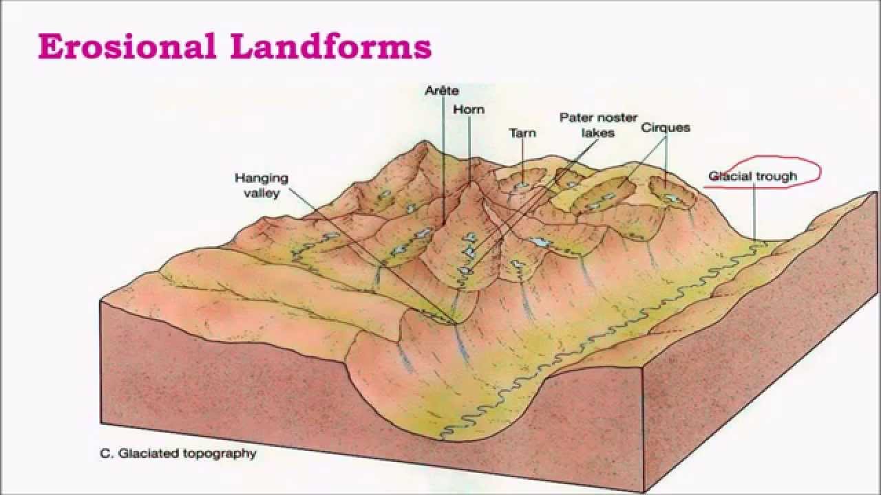
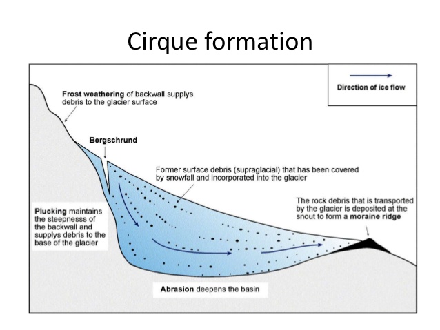
Cirque/Corrie
- Hollow basin cut into a mountain ridge.
- It has steep sided slope on three sides, an open end on one side and a flat bottom.
- When the ice melts, the cirque may develop into a tarn lake.
Glacial Trough
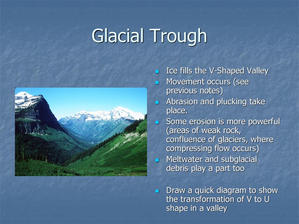
- Original stream-cut valley, further modified by glacial action.
- It is a ‘U’ Shaped Valley. It at mature stage of valley formation.
- Since glacial mass is heavy and slow moving, erosional activity is uniform – horizontally as well as vertically.
- A steep sided and flat bottomed valley results, which has a ‘U’ shaped profile.
Hanging Valley
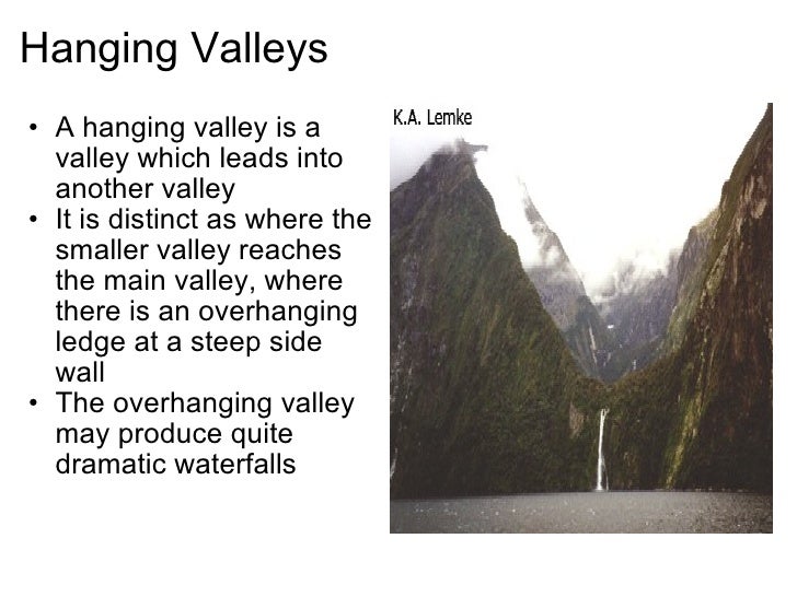
- Formed when smaller tributaries are unable to cut as deeply as bigger ones and remain ‘hanging’ at higher levels than the main valley as discordant tributaries.
- A valley carved out by a small tributary glacier that joins with a valley carved out by a much larger glacier.
Arete

- Steep-sided, sharp-tipped summit with the glacial activity cutting into it from two
Horn

- Ridge that acquires a ‘horn’ shape when the glacial activity cuts it from more than two sides.
D-Fjord

- Steep-sided narrow entrance-like feature at the coast where the stream meets the coast.
- Fjords are common in Norway, Greenland and New Zealand.
Outwash Plain
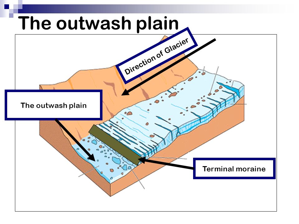
- When the glacier reaches its lowest point and melts, it leaves behind a stratified deposition material, consisting of rock debris, clay, sand, gravel etc. This layered surface is called till plain or an outwash plain.
Esker

- Winding ridge of un-assorted depositions of rock, gravel, clay etc. running along a glacier in a till plain.
- The eskers resemble the features of an embankment and are often used for making roads.
Kame Terraces
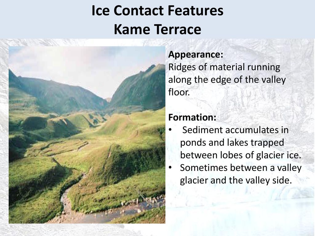
- Broken ridges or un-assorted depositions looking like hump in a till plain.
Drumlin

- Inverted boat-shaped deposition in a till plain caused by deposition.
Kettle Holes

- Formed when the deposited material in a till plain gets depressed locally and forms a basin.
Moraine
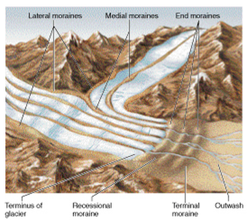
- General term applied to rock fragments, gravel, sand, etc. carried by a glacier.
- Depending on its position, the moraine can be ground moraine and end moraine.
Glacial Cycle of Erosion
Youth
- The stage is marked by the inward cutting activity of ice in a cirque.
- Aretes and horns are emerging. The hanging valleys are not prominent at this stage.
Maturity
- Hanging valleys start emerging. The opposite cirques come closer and the glacial trough acquires a stepped profile which is regular and graded.
Old Age
- Emergence of a ‘U’-shaped valley marks the beginning of old age.
- An outwash plain with features such as eskers, kame terraces, drumlins, kettle holes etc. is a prominent development.
Why are world’s highest mountains at the equator?
- Ice and glacier coverage at lower altitudes in cold climates is more important than collision of tectonic plates. [Glacial erosion is very strong because of huge boulders of rocks carried by the glacial ice that graze the surface. Though ice moves only few meters a day, it can take along it huge rocks that can peal the outer layers.]
- Scientists have solved the mystery of why the world’s highest mountains sit near the equator.
- Colder climates are better at eroding peaks. In colder climates, the snowline on mountains starts lower down, and erosion takes place at lower altitudes.
- In general, mountains only rise to around 1,500m above their snow lines, so it is the altitude of these lines — which depends on climate and latitude — which ultimately decides their height.
- At low latitudes, the atmosphere is warm and the snowline is high. Around the equator, the snowline is about 5,500m at its highest so mountains get up to 7,000m.
- There are a few exceptions [that are higher], such as Everest, but extremely few.
- When you then go to Canada or Chile, the snowline altitude is around 1,000m, so the mountains are around 2.5km.
For more such notes, Articles, News & Views Join our Telegram Channel.
Click the link below to see the details about the UPSC –Civils courses offered by Triumph IAS. https://triumphias.com/pages-all-courses.php